In this article:
What changed: The DDPM warning covers November 9–17, and a separate ONWR warning covers November 9–14. Rivers connected to the sea are forecast to exceed critical levels by 0.10–0.30 m. Forecast levels at Phra Chulachomklao Fort and readings from city stations for November 10 have been updated.Updated: November 9, 2026
What changed: A new high-tide warning is in effect from November 9 to November 17, 2026. Readings from three stations for November 8, 2026 and DDPM help contacts have been added.Updated: October 31, 2026
What changed: Morning readings from stations for October 31 have been added: the status at Pak Khlong Talat is normal, and at the Khlong Sip Sam watergate it is critical. The warning about possible flooding during high tide covers the period through November 5.Updated: October 28, 2026
What changed: The high-tide warning is in effect from October 27 to November 5 and covers Bangkok and six central provinces. Flooding is possible in low-lying areas along rivers and canals.
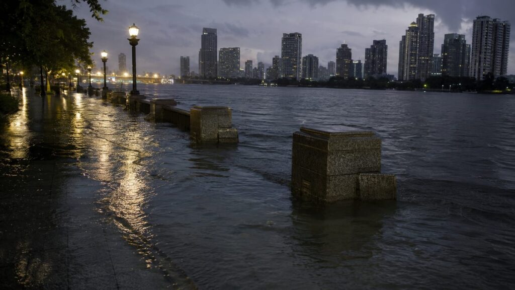
Flooding in Bangkok remains a risk for low-lying areas along rivers and canals because of high tides. Current as of November 10, 2026. The Department of Disaster Prevention and Mitigation of Thailand (DDPM) has warned of possible flooding for the period November 9–17, while the Office of National Water Resources (ONWR) issued a separate warning for November 9–14.
These are separate notices: their timing and geographic coverage do not fully match. This concerns a likely rise in water along coastal areas, not confirmed flooding of all of Bangkok. City readings also need to be read with the date, time, and station name: a normal status on one sensor does not guarantee the safety of nearby streets. Conditions can change, so check announcements from local authorities before going to the river.
What is known
The Department (DDPM) published the warning on November 6, 2026 (2569 in the Thai calendar). It specifies a high-tide period through November 17. The Office (ONWR) separately warns of risk from November 9 to 14 and forecasts that water levels on rivers connected to the sea will rise by roughly 0.10–0.30 m above critical levels. This is a forecast, not a measured depth of water on the roads.
Chao Phraya River — the main reference point for assessing conditions along the capital’s waterfront. A possible overflow of the river and canals onto their banks is mentioned in a statement from the Bangkok district administration. The Navy’s Hydrographic Department has also warned of high water levels at Phra Chulachomklao Fort. For an alternative route, see transport options in Bangkok, but information about regular transport does not confirm that piers are operating during high tide.
The end of the ONWR warning on November 14 does not cancel the DDPM warning, which is in effect until November 17.
Flooding in Bangkok: which areas are at risk
The Department (DDPM) names Bangkok and the provinces of Pathum Thani, Nonthaburi, Nakhon Pathom, Samut Sakhon, Samut Songkhram, and Samut Prakan. A separate list from the Office (ONWR) also includes Chachoengsao. The most vulnerable areas are the low banks of the Chao Phraya and its canals, communities behind protective embankments, and sections without permanent barriers.
The ONWR warning also mentions Bang Pakong River, Tha Chin River and Mae Klong River. Sukhumvit Road, Suksawat Road and Rama II Road are named as potentially vulnerable transport routes. This is not a report of their closure.
On the saved map you can find the districts Dusit, Phra Nakhon, Bang Kho Laem, Yan Nawa, Bangkok Noi and Khlong San. These are geographic reference points, not a new official list of flooded districts.
High-tide forecast: water levels and timing of the rise
For Phra Chulachomklao Fort in Samut Prakan, Thailand’s state information agency reports a forecast for November 9–17, 2026 (2569 in the Thai calendar): from 06:00 to 12:00 the water level is expected to reach 1.80–1.90 m above mean sea level at a critical level of 1.70 m.
At the Royal Thai Navy Headquarters, the forecast is different. According to the Thai news outlet Thairath, the high-tide window for November 9–16 — 07:30–13:30. Thailand’s state information agency confirms a range of 1.70–2.00 m above mean sea level at a critical level of 2.00 m. Do not confuse the two observation points: height above sea level is not the same as water depth on the street.
Water level monitoring: readings for November 10
On the official Bangkok water monitoring page readings have been published for November 10, 2026 (2569 in the Thai calendar), at 22:10 Bangkok time. These are values for the inner side of the canals and the corresponding sensor statuses, not a tide forecast for the Chao Phraya.
| Station and reference point | Level, m | Status |
|---|---|---|
| Pak Khlong Talat | 0,41 | Normal |
| Khlong Sip Sam Watergate | 0,97 | Normal |
| Sip Son Channel by Prachamran Road | 1,07 | Normal |
| Maha Sawat Canal at the temple of Wat Puranawat | 1,10 | Normal |
At the Khlong Sip Sam watergate, the warning threshold for the inner side of the canal is 1.00 m, and the critical level is 1.10 m. Five stations are under reconstruction. The old archived reference points — Phitthayalongkon School, and Bang Pu — are kept on the map, but this table does not include fresh readings for them. The “normal” status applies only to a specific sensor and moment of measurement.
What to do
The Bangkok administration recommends monitoring rising water during high tide and preparing in advance to protect homes or business premises from water seeping in. Before heading to the riverbank, check local announcements, the nearest sensor, and the measurement time. If your route runs near the Bangkok Noi Canal or Maha Sawat Canal, follow announcements from the relevant district.
In case of an incident or if help is needed, contact the department (DDPM): 1784 or via messaging app (LINE, @1784DDPM). Requests are accepted 24/7. Also useful is the emergency response procedure; if you plan a trip on the water, information about river transport in Bangkok does not replace an up-to-date announcement about the operation of a specific pier.
The risk is local, and readings are current only for a limited time. Check conditions on the city’s monitoring system and in announcements from the authorities and the Navy: warnings and measurements can change.
Frequently Asked Questions ❓
When is the high-tide warning in effect?
The Department (DDPM) gives November 9–17, 2026 (2569 in the Thai calendar), and the Office (ONWR) gives November 9–14. These are separate warnings with different coverage.
Which areas does the warning cover?
The Department (DDPM) named Bangkok and six neighboring provinces; the Office’s separate list (ONWR) includes Chachoengsao. The main risk is linked to low-lying coastal areas.
Where can I check high-tide times?
In Navy Hydrographic Department announcements for a specific location and date. The windows at Navy Headquarters and Phra Chulachomklao Fort differ.
Does the warning mean that all of Bangkok is already flooded?
No. This is a warning about the possibility of flooding, not confirmation that the whole city is flooded.
Where can I get help for the effects of high tide?
Call the Department (DDPM) at 1784 or via messaging app (LINE, @1784DDPM). Requests are accepted 24/7.
Where can I check the current water level?
On the monitoring website of the Bangkok Department of Drainage. Check the date, time, and station: the table above is a snapshot for November 10, not real-time data.
—
Sources
- Warning from the Department of Disaster Prevention and Mitigation for November 9–17
- Statement from the Bang Phlat district administration on risk zones and assistance
- Forecast of water levels and tide times from Thailand’s state information agency
- Published notice from the water resources office for November 9–14
- Warning from the Navy’s Hydrographic Department for the fort area
- Official water level monitoring in Bangkok
- Report by a Thai news outlet on high-tide times at Navy Headquarters
Prepared by MyThai.online editorial team.